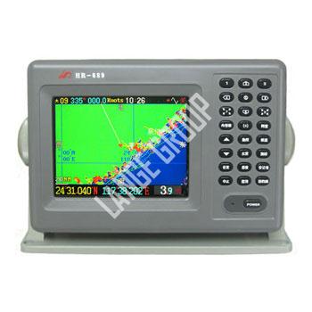
Marine Navigation System >> GPS >> Global position system(GPS)


|
|||
| Product Name | Global position system(GPS) | ||
| Product No. | MENS042-GP02 | ||
| Function Introduction | Satellite navigation |
Map,Track storage |
fish/water depth exploration |
Track: 25000 points |
fish-zone map |
Fisheries exploration frequency: 200 KHZ |
|
Destination:300 |
Solar calendar/lunar calendar |
Peak power: 250W |
|
marks set:2000 |
Simulation electron compass |
Fisheries exploration storage |
|
water lines:7 |
satellite information |
shallow/sham alarm |
|
fishes warning |
|||
screen speed tansmutability |
|||
| Specification | Machine Size:256mm ×180mm ×95mm(including machine foot) |
||
Color LCD:TFT320 ×240 display points |
|||
Ambient temperature: -10℃-+40℃ |
|||
GPS re-position time: 30 seconds or less |
|||
Geodesic of the WGS-84 (based on user requirements, can be set to test other lines) |
|||
Speed precision: 0.1 knots, heading accuracy:1° |
|||
Speed data can be an average of 16 stalls, derection data an average of 32 stalls |
|||
Bathymetric temperature accuracy: 0.1℃ |
|||
The average time of charts redraw:less than 1 second |
|||
Can store track points: 25000 points, 7 color options |
|||
Destination can be set (route points):300 |
|||
Finalized marks can be set (of points): 2000,9 kinds of shape options |
|||
Route:20 |
|||
Input and output interface specification: NMEA-0183 |
|||
Input voltage:DC11-33V,1A (standard DC+13.8V) |
|||
Charts ratio:0.01NM-500NM |
|||
Isobath (water lines) 8,of which one fixed,seven options |
|||
screen display:1.map navigation;2.compass 3.data navigation;4.Fisheries exploration |
|||
Fisheries exploration frequency: 200 KHZ |
|||
Fisheries Exploration Peak Power: 250 W |
|||
| Standard layout | usage manual |
||
633/689/636machine foot |
|||
output line NMEA-0183 |
|||
5V satellite navigation ANT used in boat |
|||
3A power line |
|||
200KHZ transducer (option) |
|||
